
报告
全球30米地表覆盖遥感制图工程
摘要
如何突破全球地表覆盖遥感制图关键技术,研制高分辨率、高质量、多时项全球地表覆盖数据产品,是近几年来国际对地观测和测绘地理信息领域面临的一个重大技术挑战。我国2010年正式启动的863重点项目“全球地表覆盖遥感制图与关键技术研究”围绕产出30米分辨率全球地表覆盖产品这一目标,以产品工程为主线,实现研究型地表覆盖遥感制图与产品工程的有机结合,完成了全球30米分辨率地表覆盖遥感制图的总体技术研究,构建包括生产技术规范、30米多源光谱影像重建、基于POK的分层分类和全过程质量控制在内的工程化产品研制方法与生产技术体系,研制出世界上首套全球两期(2000/2010)30米地表覆盖产品Globe land30。该成果已经向全球共享,在土地利用与变化、植被、农业、冰川、气候环境、城镇化、灾害研究等方面得到广泛应用,有力地推动了相关领域研究和全球对地观测数据共享。
检索正文关键字
报告目录
- 一 引言
-
二 总体思路
- (一)科学制定数据产品及技术规范,支撑标准化产品研制
- 1.地表覆盖分类体系
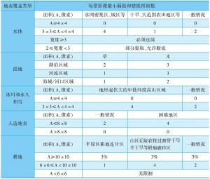
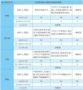
- 2.最小制图单元
- 3.数据处理方法
- (二)将全要素复杂制图分解为单要素提取与集成,实现产品的高精度研制
- (三)开展全过程质量控制,确保数据成果质量
- (一)科学制定数据产品及技术规范,支撑标准化产品研制
-
三 工程技术体系
- (一)生产技术标准与规范
- (二)30米多光谱影像重建
- (三)基于POK的分层分类
- (四)过程质量控制
-
四 规模化产品研制
- (一)影像资料收集处理
- (二)单类型提取规模化生产
- (三)多类型分类成果集成
- (四)数据产品优化完善
-
五 主要成果及应用
- (一)数据成果与服务平台
- (二)初步应用
- 六 结语
报告图片/图表


相关文献
查看更多>>>