摘要
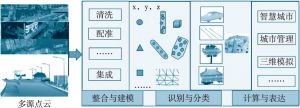
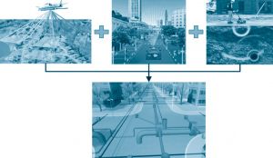
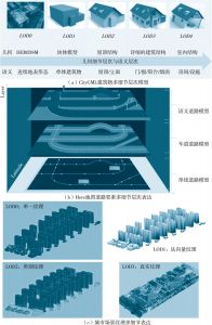
实景三维地理信息技术是以服务精细化、动态化、真实化、智能化为目标,综合利用“空-天-地-地下”数据采集手段获取城市精准空间信息并结合物联网动态传感数据,实现地上下、室内外、动静态空间数据全覆盖,为实现“像绣花一样精细”的城市管理提供翔实的信息保障。本文从实景三维地理信息的实际需求、发展机遇、建设基础、应用前景等方面进行了较为全面的阐述,从标准与规范、技术需求和建设构想几个方面对实景三维中国提出了建设性意见,从而充分发挥其在智慧城市、智慧交通、智能房管、环保监测等诸多民生领域的重要作用。
作者
李德仁 ,中国科学院院士,中国工程院院士,工学博士,武汉大学测绘遥感信息工程国家重点实验室,研究方向为遥感、全球卫星定位和地理信息系统。
杨必胜 ,教授,工学博士,研究方向为三维地理信息获取与分析。
董震 ,副研究员,工学博士,武汉大学测绘遥感信息工程国家重点实验室。
- [1]杨必胜、梁福逊、黄荣刚:《三维激光扫描点云数据处理研究进展、挑战与趋势》,《测绘学报》2017年第46(10)期,第1509~1516页。
- [2]刘先林:《为社会进步服务的测绘高新技术》,《测绘科学》2019年第44(6)期,第1~15页。
- [3]Yang B.,Dong Z.,Liang F.,et al.,Automatic Registration of Large-scale Urban Scene Point Clouds Based on Semantic Feature Points. ISPRS Journal of Photogrammetry and Remote Sensing,2016,113:43-58.
- [4]Yang B.,Dong Z.,Zhao G.,Dai W.,Hierarchical Extraction of Urban Objects from Mobile Laser Scanning Data. ISPRS Journal of Photogrammetry and Remote Sensing,2015,99:45-57.
- [5]Yang B. S.,Dong Z.,Liu Y.,et al.,Computing Multiple Aggregation Levels and Contextual Features for Road Facilities Recognition Using Mobile Laser Scanning Data. ISPRS Journal of Photogrammetry and Remote Sensing,2017a,126:180-194.
- [6]李德仁、王密、沈欣等:《从对地观测卫星到对地观测脑》,《武汉大学学报》(信息科学版)2017年第42(2)期,第143~149页。
- [7]李德仁、马军、邵振峰:《论地理国情普查和监测的创新》,《武汉大学学报》(信息科学版),2018。
- [8]李德仁、余涵若、李熙:《基于夜光遥感影像的“一带一路”沿线国家城市发展时空格局分析》,《武汉大学学报》(信息科学版)2017年第42期,第720页。
- [9]李德仁:《从测绘学到地球空间信息智能服务科学》,《测绘学报》2017年第10期,第9~14页。
- [10]张振鑫:《基于多层次点集特征的ALS点云分类的方法与技术》,北京:北京师范大学,博士学位论文,2016。
- [11]李德仁、刘立坤、邵振峰:《集成倾斜航空摄影测量和地面移动测量技术的城市环境监测》,《武汉大学学报》(信息科学版)2015年第40(4)期,第427~435页。
- [12]于永涛:《大场景车载激光点云三维目标检测算法研究》,厦门:厦门大学,博士学位论文,2015。
- [13]王晏民、胡春梅:《一种地面激光雷达点云与纹理影像稳健配准方法》,《测绘学报》2012年第41(2)期,第266~272页。
- [14]Yang B.,Zang Y.,Dong Z.,et al.,An Automated Method to Register Airborne and Terrestrial Laser Scanning Point Clouds. Isprs Journal of Photogrammetry and Remote Sensing,2015,109:62-76.
- [15]Yang B.,Dong Z.,Dai W.,et al.,Automatic Registration of Multi-view Terrestrial Laser Scanning Point Clouds in Complex Urban Environments. Proceedings 2015 Second Ieee International Conference on Spatial Data Mining and Geographical Knowledge Services,2015:141-146.
- [16]陈良良、隋立春、蒋涛等:《地面三维激光扫描数据配准方法》,《测绘通报》2014年第5期,第80~82页。
- [17]Yang B.,Dong Z.,Liang F.,et al.,Automatic Registration of Large-scale Urban Scene Point Clouds Based on Semantic Feature Points. Isprs Journal of Photogrammetry and Remote Sensing,2016,113:43-58.
- [18]Yang B.,Zang Y.,Automated Registration of Dense Terrestrial Laser-scanning Point Clouds Using Curves. Isprs Journal of Photogrammetry and Remote Sensing,2014,95:109-121.
- [19]Yang B.,Huang R.,Li J.,et al.,Automated Reconstruction of Building LoDs from Airborne LiDAR Point Clouds Using an Improved Morphological Scale Space. Remote Sensing,2017,9(1):14.
- [20]Fang L.,Yang B.,Chen C.,et al.,Extraction 3D Road Boundaries from Mobile Laser Scanning Point Clouds. Proceedings 2015 Second Ieee International Conference on Spatial Data Mining and Geographical Knowledge Services,2015:162-165.
- [21]Yang B.,Dong Z.,Liu Y.,et al.,Computing multiple Aggregation Levels and Contextual Features for Road Facilities Recognition Using Mobile Laser Scanning Data. Isprs Journal of Photogrammetry and Remote Sensing,2017,126:180-194.
- [22]Yang B.,Xu W.,Yao W.,Extracting Buildings from Airborne Laser Scanning Point Clouds Using a Marked Point Process. Giscience & Remote Sensing,2014,51(5):555-574.
- [23]LeCUN C.,Bengio Y.,Hinton G.,Deep learning[J]. Nature,2015,521(7553):436-444.
- [24]Biljecki F.,Ledoux H.,Stoter J.,et al.,Formalisation of the Level of Detail in 3D City Modelling. Computers,Environment and Urban Systems,2014,48:1-15.
- [25]Biljecki F.,Ledoux H.,Stoter J.,An Improved LOD Specification for 3D Building Models[J]. Computers,Environment and Urban Systems,2016,59:25-37.
- [26]Verdie Y.,Lafarge F.,Alliez P. LOD Generation for Urban Scenes. ACM TRANSACTIONS ON GRAPHICS,2015,34(3):1-14.
- [27]Bolch T.,Sorensen L.,Simonsen S.,et al.,Mass Loss of Greenland’s Glaciers and Ice Caps 2003-2008 Revealed from ICESat Laser Altimetry Data. Geophysical Research Letters,2013,40(5):875-881.
- [28]Radic V.,Hock R.,Glaciers in the Earth’s Hydrological Cycle:Assessments of Glacier Mass and Runoff Changes on Global and Regional Scales. Surveys In Geophysics,2014,35(3):813-837.
- [29]Tang H.,Dubayah R.,Brolly M.,et al.,Large-scale Retrieval of Leaf Area Index and Vertical Foliage Profile from the Spaceborne Waveform Lidar (GLAS/ICESat). Remote Sensing of Environment,2014,154:8-18.
- [30]Wang Y.,Li G.,Ding J.,et al.,A combined GLAS and MODIS Estimation of the Global Distribution of Mean Forest Canopy Height. Remote Sensing of Environment,2016,174:24-43.
- [31]Biljecki F.,Stoter J.,Ledoux H.,et al.,Applications of 3D City Models:State of the Art Review. ISPRS International Journal of Geo-Information,2015,4(4):2842-2889.
- [32]Yu B.,Liu H.,Wu J.,et al.,Automated Derivation of Urban Building Density Information Using Airborne LiDAR data and Object-based Method. Landscape And Urban Planning,2010,98(3-4):210-219.
- [33]Matikainen L.,Lehtomäki M.,Ahokas E.,et al.,Remote Sensing Methods for Power Line Corridor Surveys. ISPRS Journal of Photogrammetry and Remote Sensing,2016,119:10-31.
- [34]陈驰、麦晓明、宋爽等:《机载激光点云数据中电力线自动提取方法》,《武汉大学学报》(信息科学版)2015年第40(12)期,第1600~1605页。
- [35]Rodriguez G.,Fernandez B.,Munoz A.,et al.,Mobile LiDAR System:New Possibilities for the Documentation and Dissemination of Large Cultural Heritage Sites. Remote Sensing,2017,9(3):1-17.
- [36]Cheng L.,Wang Y.,Chen Y.,et al.,Using LiDAR for Digital Documentation of Ancient City Walls[J]. Journal of Cultural Heritage,2016,17:188-193.