
章节
中国主要粮食作物遥感监测
摘要
粮食安全是“国之大者”,是经济发展、社会稳定、国家安全的重要保障。病虫害是威胁粮食安全的重要因素,年均造成全球粮食歉收40%、我国粮食损失300亿~500亿斤。本报告融合国内外GF系列、Landsat系列、Sentinel 系列等卫星遥感数据、气象数据、区划数据、地面调查数据等多源数据,实现了2022年全国小麦、水稻、玉米的种植面积提取、长势状况监测、主要病虫害生境适宜性分析和作物产量估算。研究结果表明:①2022年全国水稻、玉米整体生长状况良好,与2021年相比总体长势持平,西北麦区小麦生长状况略差,但与2021年相比偏好;②2022年全国适宜小麦条锈病、赤霉病和蚜虫传播扩散的面积约1.6亿亩,适宜水稻稻飞虱、稻纵卷叶螟、稻瘟病传播扩散的面积约1.6亿亩,适宜玉米粘虫、大斑病传播扩散的面积约7106万亩;③2022年全国小麦总产量约1.3亿吨,水稻总产量约2.1亿吨,玉米总产量约2.6亿吨。
作者
检索正文关键字
章节目录
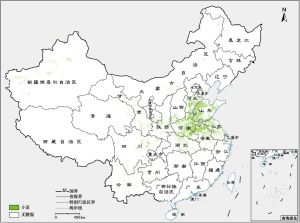
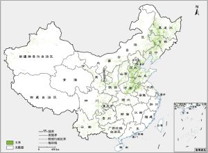
- 4.1 中国主要粮食作物种植区遥感监测
-
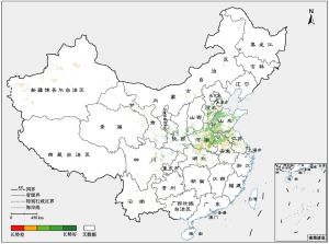
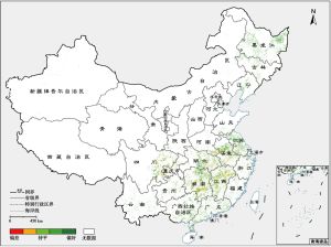
4.2 中国主要粮食作物长势遥感监测
- 4.2.1 小麦长势对比分析
- 4.2.2 水稻长势对比分析
- 4.2.3 玉米长势对比分析
-
4.3 粮食作物重大病虫害生境适宜性分析
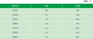
- 4.3.1 小麦病虫害生境适宜性分析
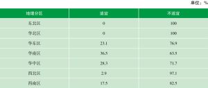
- 4.3.2 水稻病虫害生境适宜性监测
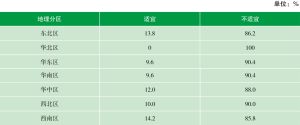
- 4.3.3 玉米病虫害生境适宜性监测
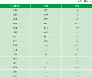
- 4.4 中国主要粮食作物产量遥感估测
章节图片/图表


查看更多>>>